Professional Weather Forecasts in Your Pocket
Access 13 global forecast models, interactive diagrams, live radar, and ensemble predictions — all in an intuitive, powerful interface built for meteorology enthusiasts and outdoor professionals.

Access 13 global forecast models, interactive diagrams, live radar, and ensemble predictions — all in an intuitive, powerful interface built for meteorology enthusiasts and outdoor professionals.
From hourly forecasts to live radar and compass navigation.
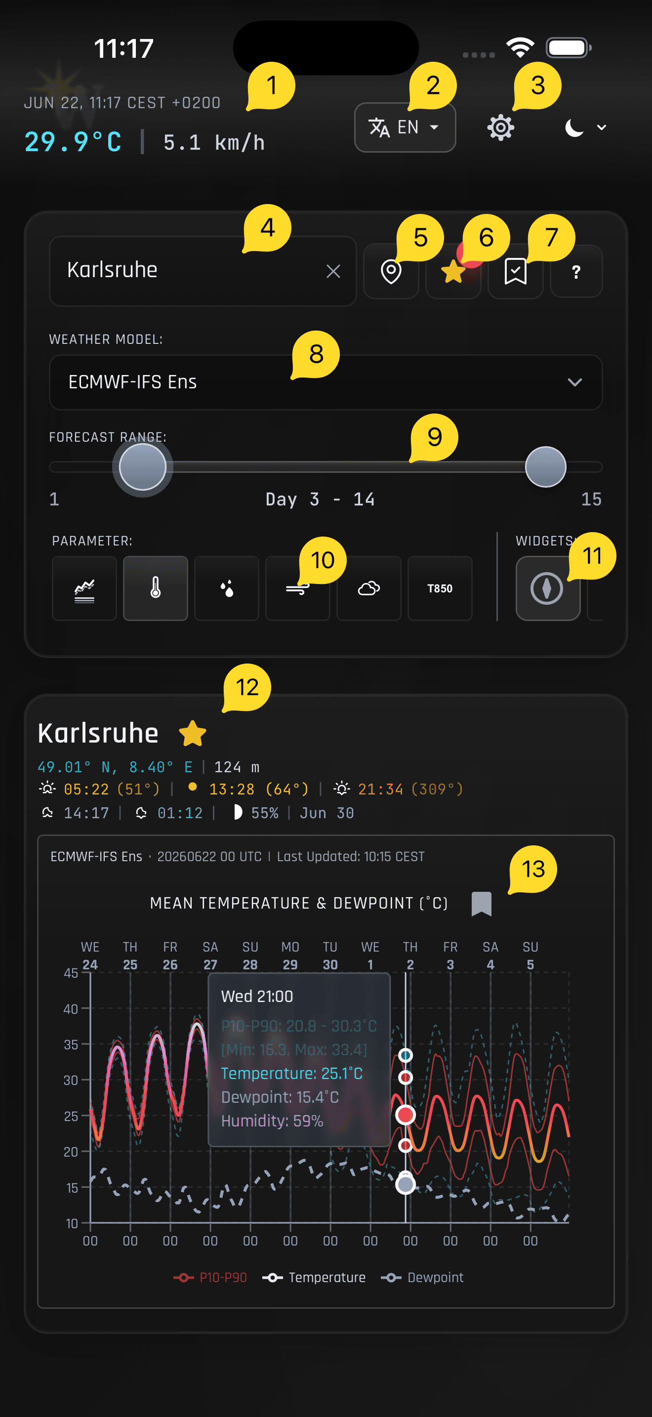
Find any location by name or use your device's GPS. Recent searches are remembered for instant access.
Save locations, rename them, and sort by recency, alphabetically, or by distance from you.
Switch between ECMWF, GFS, ICON, UKMO, Météo-France, ensemble runs, AI-driven AIFS, and more.
Temperature, Precipitation, Wind, Cloud Cover, 850 hPa, Combined Overview, and UV Index.
Dual-handle slider lets you zoom from 3 days up to the model's maximum range (up to 16 days).
Hover on desktop or tap on mobile to read exact values at any time step.
Real-time conditions, sunrise/sunset azimuth, moon phase, and illumination.
Animated precipitation radar with opacity control, zoom, and a compass arrow at the crosshair.
Device heading with sunrise and sunset direction indicators.
View all your favorite stations on an interactive topographic map.
Save specific diagrams for offline access with the bookmark icon.
English, Deutsch, Français, Español, Italiano, Nederlands, Português, Polski, Türkçe, Ελληνικά, 日本語, 简体中文, 繁體中文.
Automatic system preference detection or manual toggle.
13 forecast models from the world's leading meteorological agencies.
| Model | Provider | Type | Resolution | Forecast Range | Region |
|---|---|---|---|---|---|
| ECMWF-IFS | ECMWF (Europe) | Deterministic | ~9–25 km | 15 days | Global |
| ECMWF-AIFS | ECMWF (Europe) | AI / ML | ~25 km | 15 days | Global |
| ICON | DWD (Germany) | Deterministic | ~11 km | 8 days | Global |
| UKMO | UK Met Office | Deterministic | ~10 km | 7 days | Global |
| GFS | NOAA / NCEP (USA) | Deterministic | ~13 km | 16 days | Global |
| Météo-France | Météo-France | Deterministic | ~11–25 km | 4 days | Global |
| ECMWF-IFS Ens | ECMWF | Ensemble | ~25 km | 15 days | Global |
| ECMWF-AIFS Ens | ECMWF | Ensemble | ~25 km | 15 days | Global |
| ICON Ens | DWD | Ensemble | ~11 km | 8 days | Global |
| GFS Ens | NOAA | Ensemble | ~13 km | 16 days | Global |
| ICON D2 Ens | DWD | Ensemble | ~2 km | 3 days | Central Europe |
| ECMWF 46d | ECMWF | Seasonal | ~25 km | 7 days (weekly) | Global |
| UV Index | CAMS + GFS | Deterministic | ~25 km | 5 days | Global |
Ensemble models run multiple simulations with slightly different starting conditions. The app visualizes the P10–P90 spread so you can see forecast uncertainty at a glance. Wider spreads mean lower confidence.
AIFS is ECMWF's AI-driven forecasting system that uses machine learning trained on decades of weather data.
The screenshot below shows key areas of the app. Each numbered item is explained in the list beneath the image.
Download WZ Diagrams today and experience weather data like never before. Available as a Progressive Web App — install directly from your browser.
Or use the app instantly in your browser — no installation required.